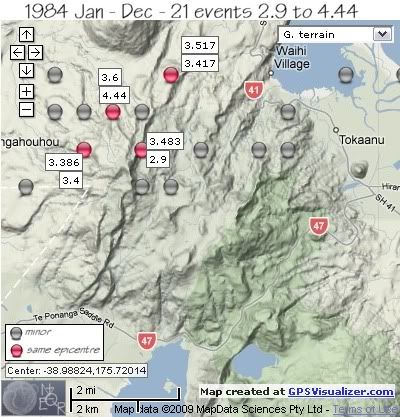
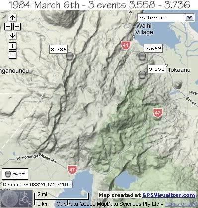
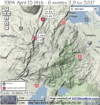
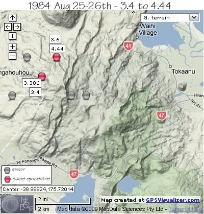
There were 3 series of events of note, 6th March, 13th – 14th April and 25th-26th August.

The first sequence of 1984 was on 6th March with 3 minor events within 49 minutes of each other, the first quake under the northern foothills of Mt. Tihia NW of Tokaanu, the 2nd quake further to the west under Mt. Kakaramea just west of the Waihi River and the 3rd quake back under the Mt. Tihia foothills, south of the first quake.
REF, LAT, LONG, TIME, DEPTH, MAG
1565057, -38.96, 175.75, 1984/03/06 05:01:50.2, 1, 3.669
1565059, -38.96, 175.7, 1984/03/06 05:11:01.0, 6, 3.736
1565061, -38.97, 175.75, 1984/03/06 05:50:07.7, 1, 3.558

two further minor quakes in March and early April;
REF, LAT, LONG, TIME, DEPTH, MAG
1565072, -38.95, 175.67, 1984/03/09 21:54:08.7, 10, 3.717
1565146, -38.97, 175.74001, 1984/04/03 09:55:58.7, 5, 3.236
Swarm of 13th –14th April started on the 13th April with 2 quakes at the same location 45 seconds apart, SE of Mt. Kuharua, followed by another 15 hrs later under the summit of Mt. Kakaramea of 3.483ML.
It was another 9hrs before the next earthquake to the west of Mt. Kakaramea, followed by a 3.45ML in Tokaanu Bay and finished with a 2.9ML back at the location of the 3.483ML.
REF, LAT, LONG, TIME, DEPTH, MAG
1565184, -38.95, 175.71001, 1984/04/13 01:34:31.6, 6, 3.417
1565185, -38.95, 175.71001, 1984/04/13 01:35:16.4, 5, 3.517
1565189, -38.97, 175.7, 1984/04/13 16:49:58.7, 2, 3.483
1565191, -38.96, 175.67999, 1984/04/14 02:08:01.2, 5, 3.225
1565192, -38.95, 175.77, 1984/04/14 08:52:54.0, 2, 3.45
1565194, -38.97, 175.7, 1984/04/14 09:20:25.1, 5, 2.9

One quake located on the north side of Tongariro River Delta on the 15th, not part of either swarm.
1565197, -38.95, 175.78999, 1984/04/15 00:49:37.6, 5, 3.46
The swarm of 25th –26th August to the NW of Mt.Tihia, started with an isolated 3.888ML in the western foothills of Mt. Kakaramea, followed by a 3.7ML 2.2km to the NNE 2 ¼ hrs later. 33 seconds later the largest quake of 1984 ( the 4.44ML) hit, 2km east.
It was another 4 hrs before the 3.4ML, 2km south of the previous 3 events, followed 1 ½ hrs later by a 3.386ML at the same location.
The swarm finished rapidly, with 3 events within 3 minutes, 2 to the east of Mt.Kakaramea summit and one back at the same location as the 4.44ML.
REF, LAT, LONG, TIME, DEPTH, MAG
1565566, -38.98, 175.66, 1984/08/25 20:32:01.1, 5, 3.888
1565567, -38.96, 175.67, 1984/08/25 22:48:11.6, 5, 3.7
1565568, -38.96, 175.69, 1984/08/25 22:48:44.4, 5, 4.44
1565569, -38.97, 175.67999, 1984/08/26 03:55:57.4, 5, 3.4
1565570, -38.97, 175.67999, 1984/08/26 05:39:28.0, 5, 3.386
1565571, -38.98, 175.7, 1984/08/26 05:44:13.7, 5, 3.567
1565572, -38.96, 175.69, 1984/08/26 05:45:35.8, 5, 3.6
1565573, -38.98, 175.71001, 1984/08/26 05:46:04.6, 5, 3.82

The year finished with one other event in December, 1km NNW of Mt. Tihia summit.;
REF, LAT, LONG, TIME, DEPTH, MAG
1565841, -38.97, 175.72, 1984/12/03 17:15:09.7, 11, 3.418
data by geonet. map by google maps. plots by highace using GPS Visualizer

No comments:
Post a Comment