REF, LAT, LONG, TIME, DEPTH, MAG
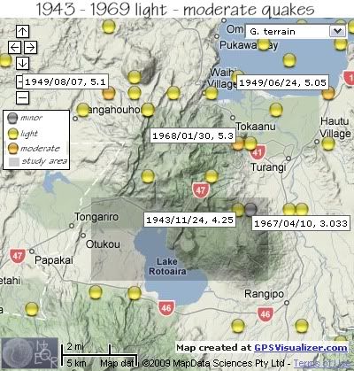
1542420, -39.02, 175.77, 1943/11/24 14:28:35.0, 115, 4.25
1549534, -39.02, 175.78, 1967/04/10 14:36:26.3, 12, 3.033, FELT
(These are shown on the map below within the shaded study area)
Otherwise during the same period there were within a 15km radius of Mt Tihia some 25 events 4.0 to 5.3Ml. (Only the magnitude 5+ are tagged on the map.)

REF, LAT, LONG, TIME, DEPTH, MAG
1585334, -39, 175.75, 1942/04/30 09:09:42.4, 12, 4
1585337, -39.09, 175.77, 1942/05/08 04:12:22.3, 12, 4.267
1542438, -39.02, 175.81, 1944/01/10 04:39:15.0, 12, 4.633
1542569, -38.95, 175.69, 1944/10/26 21:29:36.5, 163, 4.85
1542698, -39, 175.7, 1945/10/12 04:18:38.9, 12, 4.2
1542848, -38.98, 175.78, 1946/06/28 11:50:20.0, 12, 4.333
1542942, -39.09, 175.82, 1946/12/14 22:17:07.7, 12, 4.533
1543234, -38.94, 175.77, 1948/01/26 11:54:01.4, 121, 4.75
1543518, -39.02, 175.82, 1949/05/17 02:11:06.2, 125, 4.6
1543547, -38.95, 175.84, 1949/06/24 22:14:19.9, 168, 5.05
1543568, -38.95, 175.72, 1949/07/19 17:07:16.6, 182, 4.55
1543584, -38.95, 175.67, 1949/08/07 22:10:05.0, 182, 5.1
1543702, -38.91, 175.67, 1949/12/24 09:24:13.7, 160, 4.1
1543913, -38.89, 175.62, 1950/07/22 08:24:46.4, 12, 4.333
1544782, -39.07, 175.69, 1953/08/29 02:44:41.2, 112, 4.1
1545136, -38.96, 175.8, 1954/10/01 07:30:45.4, 65, 4.3
1545359, -38.83, 175.81, 1956/01/13 07:23:03.2, 139, 4.1
1545397, -38.95, 175.75, 1956/03/05 01:21:43.7, 12, 4.1
1545686, -38.94, 175.69, 1957/11/08 23:00:23.6, 128, 4.4
1545864, -39.08, 175.61, 1959/02/10 16:22:21.4, 118, 4.15
1545873, -39.07, 175.66, 1959/02/27 05:58:24.5, 126, 4.2
1546365, -38.93, 175.59, 1960/11/15 17:36:39.6, 207, 4.1
1547213, -38.96, 175.65, 1962/10/01 22:37:08.6, 12, 4
1549545, -38.98, 175.84, 1967/04/20 04:40:49.7, 12, 4.176
1549977, -38.98, 175.77, 1968/01/30 05:38:54.2, 12, 5.3
data by geonet. map by google maps. plots by highace using GPS Visualizer

No comments:
Post a Comment